

")
Publication History
Submitted: October 31, 2024
Accepted: November 22, 2024
Published: March 31, 2025
Identification
D-0411
DOI
https://doi.org/10.71017/djnsi.4.3.d-0411
Citation
Ujala Shah (2025). Assessment of Changes in the Ponds and their Services in Janakpur Sub-Metropolitan City. Dinkum Journal of Natural & Scientific Innovations, 4(03):181-194.
Copyright
© 2025 The Author(s).
181-194
Assessment of Changes in the Ponds and their Services in Janakpur Sub-Metropolitan CityOriginal Article
Ujala Shah 1*
- Nepal Engineering College, Changunarayan, Bhaktapur, Pokhara University, Nepal.
* Correspondence: er.ujalashah@gmail.com
Abstract: Nepal has abundant water resources, but attention is mainly focused on large rivers, lakes, groundwater, and glaciated water. Ponds, wells, stone spouts, and springs are often overlooked. Urbanization has led to land use changes, conversion of agricultural land into housing, and increased land prices, causing the disappearance and degradation of indigenous water systems. This study examined the urban landscape of Janakpur, Nepal, and the impact of land use changes on local ponds. It focuses on four key considerations: the large network of ponds, changes in traditional pond systems due to urbanization, environmental consequences of increased water pollution, urban flooding, and water and vector-borne diseases, and the importance of conservation in urban development policies. The findings will inform planning for ‘Greater Janakpur’ and other central and eastern Terai districts. This study explored the Janakpur Sub-Metropolis, a city in India’s central Terai region, focusing on its importance in pond conservation and management. Established in 1962, it has a population of 194,556 and a density of 2,115 people per km2. This study used a mixed method approach, including map analysis, group discussions, and in-depth interviews with key informants. It assesses pond changes and their environmental services in three spatial categories: densely populated urban core, rapidly expanding urban sprawl, and rural fringe areas. This study also reviewed past research and commissioned studies on local water systems in the Terai region. Janakpur, known as the city of ponds, has a rich history of temples, ponds, and human settlement. Its ancient capital, Videha, was the center of Maithil civilization. Important ponds hold religious importance for Hindu pilgrims. However, some ponds have disappeared due to encroachment and neglect. There are no authentic records or scientific studies on ponds’ hydrological and ecological importance. Urbanization in Janakpur, India has increased pond coverage, affecting groundwater recharge and pollution. Flooding and inundation events have also affected the local cultural legacy and economy. The government’s focus on improving ponds has complicated the relationship between infrastructural improvements, cultural relevance, and environmental sustainability. Sustainable pond management is crucial for water sustainability.
Keywords: Nepal, ponds, water, urban, environmental, Janakpur, India
1. INTRODUCTION
Nepal has abundant water resources, with an estimated 220 and 80 billion cubic meters of renewable surface and groundwater potential, resulting in a per capita water availability of nearly 8,900 m3/annum. These resources include rainfall, snow, glaciers, water flowing through over 6000 rivers and streams, and water stored annually in lakes, ponds, and groundwater aquifers [1]. The major usable water resources include big rivers from the Himalayas, perennial and seasonal streams, and the rich groundwater reserve in the Terai and hill river valleys. However, attention to water resources management in Nepal is largely focused on large rivers, lakes, groundwater, and glaciated water, while smaller water systems such as ponds, wells, stone spouts, and springs often do not get much attention. Ponds are water confined to an enclosure formed by natural depression or purposive excavation and embankment development by the people living in the area with the aim of creating storage for domestic and agricultural uses and for the culture fishery [2]. In Nepal, an intense network of ponds is located in the flood plains of major river basins in the Terai, such as Bagmati and Koshi. Ponds in the region are intricately linked to the culture and livelihoods of the people, as they bathe, perform cleaning and washing, use the stored water for livestock watering, and provide lifesaving irrigation in the dry season when no other source of water is available. Temples and places to worship the deities are often located around the ponds, and the ‘Chhath’ festival, celebrated in October-November, is celebrated around the ponds. Ponds are also used to rare fishes, both wild and carp, for culture fishery, which is an important source of protein in the daily food menu of the people and has emerged as a promising agricultural enterprise in many areas of central and eastern Terai. Some water vegetation grows in ponds and lakes, such as Fox Nut (Eury old ferox) and water Chest Nut (Eleocharis dulcis), which fetch high market prices due to their demand in the local market and outside [3]. The cultural and livelihood importance of ponds in the Terai region and other parts of Nepal is widely recognized, but there is no systematic documentation of their number, area, and volume. The Agricultural Census of Nepal, carried out every ten years by the National Statistics Office (NSO), includes estimates of land area under ponds and the number of farm holdings who own them [4]. Limited studies have been conducted in Nepal to document and unfold the social, economic, environmental, cultural, and livelihood importance of ponds. The lack of documentation on ponds and their importance to support and maintain the wellbeing of the people and the local environment has led to the conservation and management of ponds being largely ignored. Urbanization has led to land use changes, rampant conversion of agricultural land into housing plots, and increased land prices in urban areas, leading to many ponds being filled up by the people [5]. These ponds have also become breeding grounds for insects and pests, which are sources of vector-borne diseases. The immediate impact of urbanization is the disappearance and degradation caused to indigenous water systems like wells, ponds, or stone spouts. Rampant infrastructure development in urban areas has impeded natural drainage and loss of open land for recharge, disrupting the flow path to the ponds [6]. Increased incidences of flooding and inundation in urban areas in the Terai region in recent years are often attributed to changes in the natural drainage system and losses of areas under natural depressions and ponds to buffer overland flow. Governments, development organizations, and civil society have not been proactive in protecting freshwater systems like ponds and lakes [7]. The Provincial Government of the Madhesh Province initiated a pond rehabilitation program under Mukhymantri Swakshata Abhiyan, but this effort has been focused largely on physical construction in and around ponds rather than improving pond hydrology and ecosystem. This study aimed to map and assess the changes in ponds and their environmental services in the rapidly urbanizing Janakpur sub-metropolitan city, aiming to inform the imperative of conservation and management of ponds [8]. It is importance in the governance architecture of the country, which entrusts local governments to function as custodians of water resources at the local level and proactively support the conservation and management of water systems that produce value to society and the local environment. It focused on the urban landscape of Janakpur sub-metropolis, focusing on the patterns of land use changes and their impact on local ponds. It explores the importance of ponds and their environmental services in sustaining water security for urban living and the sensitivity of local, provincial, and federal governments in integrating ponds into urban development policies and programs. The study is based on four key considerations: the large network of ponds within the sub-metropolis boundary, the changes in traditional pond systems due to urbanization, the environmental consequences of increased water pollution, urban flooding, and increased incidences of water and vector-borne diseases, and the importance of conservation of ponds and their environmental services in the urban development policy of the sub-metropolis. The city is also a significant pilgrimage destination for Hindus in Nepal and around the world, making the conservation of ponds and their environmental services crucial for the city’s well-being. This study mapped and assessed the importance of ponds and their environmental services in the changing landscape of Janakpur Sub-Metropolis, Nepal. It includes analyzing the pattern of changes in pond existence and area in relation to land use changes, assessing the environmental services of ponds in terms of their importance in provisioning goods and services to sustain livelihoods, and assessing the ongoing efforts on conservation and management of ponds by local and provincial governments.
2. MATERIALS AND METHODS
This study examined Janakpur Sub-Metropolis, a city in the central Terai region of Madhesh Province, India. As the ancient capital of Mithila and birthplace of Sita, Janakpur is a center of learning and enlightenment. It is the third largest city in the Terai region and the seventh largest in the country. Janakpur is surrounded by five major rivers and has a tropical climate. Established in 1962, it was upgraded to a Sub-Metropolis in 2015, expanding its geographical area and urban governance structure. The city has a population of 194,556, with a density of 2,115 people per km2. The population growth rate between 2011 and 2021 was 1.7% per annum, higher than the national rate of 0.92% [9].
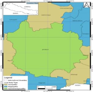
Figure 01: Location Map of Janakpur Sub-Metropolitan City
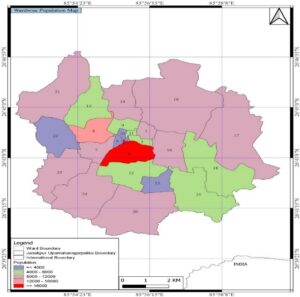
Figure 02: Distribution of population density by wards
The study utilized a mixed method approach, including map analysis, group discussions, and in-depth interviews with key informants, including elderly citizens, social leaders, and decision-making personnel. This study involved reviewing secondary sources, assessing pond changes in relation to urban growth, assessing environmental services, mapping water stresses, and synthesizing information to derive implications for conservation and management of ponds in Janakpur’s urban landscape. The methodological framework is presented in figure.
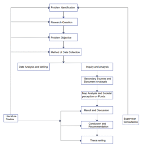
Figure 03: Methodological Framework of the Study
This study examined the importance of ponds in the Janakpur Sub-Metropolis, focusing on their conservation and management efforts. Secondary sources and document analysis were used to understand the policies and programs of the Janakpur Sub-Metropolitan Corporation, Greater Janakpur City Development Council, and water resources development programs of Madhesh Province. This study also reviewed past research and commissioned studies on local water systems in the Terai region to understand their social, economic, and cultural importance. Maps and remote sensing data were analyzed to assess the growth patterns and pond coverage over different time periods. The inventory of ponds was validated through key informants’ interviews in different wards of the sub-metropolis. This study aimed to assess changes in ponds and their environmental services in Janakpur Sub-Metropolis, focusing on three spatial categories: densely populated urban core, rapidly expanding urban sprawl, and rural fringe areas. The urban land use map of Janakpur Metropolis for 2022 was used to mark the boundary of these categories.
Table 01: Key features of the spatial categories of cityscape used in the study to base the assessment of ponds in the study.
| S/N | Category of cityscape | Wards | Area (ha) | Population density (people/ha) * | Remarks |
| 1. | Urban core | 1,2,3, 4,5,
6,9,10,11 |
543 | 241.50 | Dense population and urban infrastructures. |
| 2. | Rapidly expanding urban sprawl | 7,8,12,
13,14,15 |
1593 | 14.17 | Expanding population and density of urban infrastructure, radially from the city core through conversion of agricultural land uses. |
| 3. | Rural fringe | 16,17,18,19,
20,21,22, 23,24,25 |
7059 | 1.87 | Less dense population and infrastructures with crop and livestock farming as major source of occupation and income. |
| Total | 9195 | 257.55 | |||
A study was conducted to assess the environmental services produced by ponds in different cityscapes. The Millennium Ecosystem Assessment Report (2005) identified four services: provisioning services (water provision for domestic and agricultural uses), regulating services (balancing flood-drought cycles), support services (assimilation of solid and liquid wastes, temperature regulation), and cultural services (religious, cultural, and aesthetic values of water systems) [10]. The mapping of these services was done using information provided by users and those living in the vicinity. The value of these services was assessed based on perceived value. A cross-section of people in the urban area of Janakpur Sub-Metropolis was surveyed to compare the importance of ponds and the adequacy of conservation and management efforts. The results were used to assess the adequacy of restoration and rehabilitation programs by the municipal government and Greater Janakpur City Development Council. This study aimed to produce context-specific information on ponds and their environmental services in Janakpur without generalizing findings to other urban areas.
Table 02: Objective wise research matrix
| Objective | Data needs | Methodology/Tools | Output |
| To map and analyze the pattern of changes in the existence and the area of ponds in relation to the land use changes in the Janakpur Sub-Metropolis. | Number, location and areas of ponds and the changes thereto | Analysis in GIS environment using remote sensing data products (Topo map, Landsat image for 1992,2006,2017 and 2022. | The changes in the number and location of the ponds |
| To assess the environmental services of ponds in terms of their importance in provisioning goods and services to sustain the livelihoods of the people and also in maintain the social, cultural, and religious importance and aesthetics of the city. | Environmental functions and service of the ponds- Provisioning, Regulating, Support and Cultural | FGDs and KIIs in the neighbourhood of selected ponds | Assessment of environmental services of the ponds as perceived by the people in the area |
| To assess the ongoing efforts on the conservation and management of ponds by the local and provincial governments and their values in sustaining the environmental service of the ponds. | Policies, programs and impacts of ponds conservation and restoration, those rolled in the past and currently underway | Review of secondary sources and document analysis, KIIs | Efficacy of pond conservation and restoration and urban development policy and program’s |
3.RESULT & DISCUSSION
Janakpur, known as the city of ponds, has a rich history of temples, ponds, and human settlement. The city’s ancient capital, Videha, was the center of the Maithil civilization. Important ponds in the city include Biharkunda, Agnikunda, Ratnasagar, Suryakunda, Papmochanisar, Parashuramkunda, Rukminisar, Muralisar, Ramsar, Telaha-Marha, Dasharath Lake, Argajja Pond, Gangasagar, and Dhanush Sagar. These ponds hold religious importance for Hindu pilgrims, who consider the water and soil sacred. However, some ancient ponds, such as Janak Sarovar, Amrit Kunda, Yashwini Sar, and Baldeve Sar, have disappeared due to encroachment and neglect in conservation and management. There are no authentic records available on the number of ponds, their origin, construction year, or motif of rulers and religious leaders. There is also a lack of scientific inquiries and studies on the hydrological and ecological importance of ponds in the cityscape. The distribution of ponds in the cityscape is divided into rural fringe, rapidly expanding urban sprawl, and urban core areas [11].
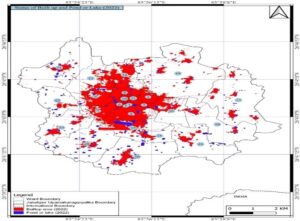
Figure 04: Urban land use of Janakpur Sub-Metropolis
The distribution of ponds in Janakpur is divided into religious/cultural, fishery, irrigation, multipurpose, and wastewater ponds. Religious and cultural ponds are located in the core urban areas, while fishery ponds are used by farmers for income. Irrigation ponds store water for dry season irrigation, while multipurpose ponds are used for multiple purposes, including fishery, irrigation, and water vegetation cultivation. Wastewater ponds, which have become receptacles of rainwater or urban wastewater, have important environmental functions, such as buffering excess rainfall-runoff and contributing to groundwater recharge. These ponds do not have tangible economic uses. The distribution of ponds in Janakpur reflects the co-existence of rural and urban contexts across the cityscape, with ponds developed for fishery and irrigation in crop farming still existing in core urban areas and rapidly growing urban sprawl [12].
Table 03: Distribution of Ponds by Purpose/Uses in Janakpur Sub-Metropolis
| S/N | Spatial category of urban area | Number and area of ponds by purpose/use category | ||||
| Religious/cultural ponds | Fishery ponds | Irrigation ponds | Multipurpose ponds | Wastewater ponds | ||
| 1. | Urban core area | 24 | 2 | 2 | 9 | 2 |
| 2. | Rapidly expanding urban sprawl | 19 | 32 | 10 | 24 | 3 |
| 3. | Rural fringe | 2 | 148 | 114 | 167 | 20 |
| Total | 45 | 160 | 148 | 200 | 25 | |
The Janakpur Sub-Metropolis has multiple ownership of ponds, including religious and cultural ponds, community ponds, and private ponds owned by individual households. The Guthi, an institution managing socio-cultural activities, has control over 16 religious and cultural ponds, while the rest are under the Janakpur Sub-Metropolitan City Council’s control. Community ponds, on public land or developed by large landlords, are managed by the Janakpur Sub-Metropolitan City Council’s Ward Offices. Private ponds are used for culture fishery and irrigation. The distribution of ponds by ownership shows the largest number of private ponds [13].
Table 04: Distribution of ponds by ownership in Janakpur Sub-Metropolis
| S/N | Spatial Category of urban area | Number and area of ponds by ownership | ||
| Guthi Ponds | Community Ponds | Private Ponds | ||
| 1. | Urban core area | 16 | 12 | 0 |
| 2. | Rapidly expanding urban sprawl | 0 | 30 | 43 |
| 3. | Rural fringe | 0 | 143 | 193 |
| Total | 16 | 185 | 236 | |
Table shows the average size of ponds in cityscapes, with religious and cultural ponds being larger and community ponds being smaller. Religious and cultural ponds are used for rituals and bathing by large numbers of pilgrims or devotees. These ponds are also used for the Chatth Festival, a four-day festival in north Indian states. Private ponds for fishery and irrigation are generally smaller, with the average size of culture fishery ponds in Janakpur being 0.12 ha, which is similar to the average size of 0.32 ha ponds in Terai.
Table 05: Average size of ponds by purpose/intended use in Janakpur Sub-Metropolis
| S/N | Spatial category of urban area | Size of the ponds by the purpose/intended use | ||
| Religious/cultural pond (ha) | Community pond (ha) | Private pond (ha) | ||
| 1. | Urban core area | 1.33(0.29-3.26) | 0.16(0.07-0.28) | 0 |
| 2. | Rapidly expanding urban sprawl | 1.63(0.95-3.53) | 0.50 (0.25-0.94) | 2.33 (0.06- 16.91) |
| 3. | Rural fringe | 3.59(3.11-4.08) | 0.84 (0.42-2.53) | 0.22(0.03-0.42) |
*Values in the parenthesis present the range This study analyzed the temporal changes in pond numbers and water surface area over four time periods (1992, 2006, 2017), covering three spatial categories of Janakpur’s cityscape, as shown in table.
Table 06: Changes in the number and water surface area of ponds over the period 1992-2022
| S/N | Spatial category of cityscape | Number and water surface area of ponds by time | |||
| 1992 | 2006 | 2017 | 2022 | ||
| 1. | Urban core area | 52(30.18) | 41(28.19) | 25(21.33) | 28(23.39) |
| 2. | Rapidly expanding urban sprawl | 93(66.37) | 75(64.9) | 72(67.09) | 73(66.33) |
| 3. | Rural fringe area | 227(122.24) | 224(115.78) | 303(134.68) | 336(169.41) |
| Total | 372(218.79) | 340(208.87) | 400(243.1) | 437(259.13) | |
*Values in the parenthesis provide water surface area of the ponds in ha
The urban core of Janakpur, which includes temples, ponds, and residential areas, has experienced radial expansion due to the development of radial road networks connecting the city core with rural areas. This growth in urban sprawl in the periphery has been dynamic, progressively expanding over time. The number and water surface area of ponds in the city have increased in rural fringe areas but decreased in the core city area. The urban sprawl remains essentially unchanged between 1992 and 2022 [14].
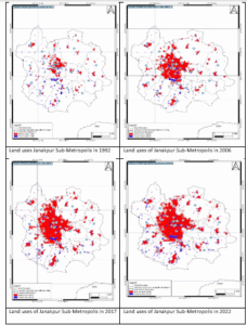
Figure 05: Land use of Janakpur Sub-Metropolis 1992,2006,2017 and 2022
The number and water surface areas of ponds in Janakpur have been impacted by land conversions. The urban core area has seen a reduction in ponds due to encroachment and filling for housing plots and service infrastructures. Community and religious ponds have been neglected, with the management of these ponds being ineffective. The Janakpur Sub-Metropolitan City Council and political influential individuals have been responsible for much of the encroachment. The peripheral areas have seen an increase in pond area, particularly in rural areas, where new fish ponds have emerged. This is driven by economic incentives of culture fishery compared to traditional cereal farming. The availability of a stable market and the availability of fish in the Mithila region have also incentivized farmers to invest in fishery. The pattern of changes between 1992 and 2022 shows a large increase in pond coverage in rural fringe areas and a reduction in urban core areas [15].
Table 07: Changes in the number and water surface area of ponds in Janakpur Sub-Metropolis between 1992 and 2022 by cityscape category
| S/N | Category of cityscape category | Change in the number of ponds between 1992 and 2022 | Change in the area (ha) under ponds between 1992 and 2022 | ||||
| 1992 | 2022 | Change (+/-, %) | 1992 | 2022 | Change (+/- %) | ||
| 1. | Urban core area | 52 | 28 | -24 (-46.15) | 30.18 | 23.39 | -6.79 (-22.49) |
| 2. | Rapidly expanding urban sprawl | 93 | 73 | -20 (-21.50) | 66.37 | 66.33 | -0.04 (-0.06) |
| 3. | Rural fringe area | 227 | 336 | +109(+48.02) | 122.24 | 169.41 | +47.17 (38.59) |
The development of smaller ponds in the Terai region is a result of people extracting mud to build and repair mud houses, which are then refilled with rainwater and surface runoff. This practice helps maintain the pond’s geometry as a storage space for runoff. In western Terai, a traditional institutional arrangement called Gadahi was used to remove silt from community ponds [16]. Rural areas in the fringe of Janakpur Sub-Metropolis supply construction materials, such as bricks, sand, and soil, needed for residential and commercial buildings. As many as 10 brick kilns are found in operation in the fringe areas, converting private land into fish ponds after the lease period ends. This has led to an increase in the number and water surface area of fish ponds in the periphery of Janakpur Sub-Metropolis. The mapping and assessment of environmental services of ponds in Janakpur Sub-Metropolis are based on perceived benefits, relationships, and services produced by the ponds, such as water supply and flood control. The connection between ponds and the ways of life of people in the Mithila region is evident through the reference to fish, fox nut, and betel leaf. Further research is needed to identify and quantify the services produced by ponds in qualitative terms [17]. Water retained in ponds during the monsoon season is crucial for providing dry season irrigation to crops grown around its periphery. Before 1970, ponds and dug wells were the only means of irrigation across the Terai region. Farmers used traditional water lifting devices to draw water from ponds and dug wells to irrigate crops during prolonged dry spells. Despite increased access to modern irrigation methods, smallholder farmers still rely on pond water and dug wells [18]. The area under pond irrigation is estimated to be 1.46% of the total irrigated area in Terai, with 3.5% of farm holdings having private farm ponds. The Terai region faces a food-drought cycle each year, with drought frequency increasing and becoming a key cause of crop yield losses. Lifesaving irrigation provided by ponds carries significant importance not only to save crops but also to assure some yield from crop harvest, even though suppressed. In rural fringe areas of Janakpur Sub-Metropolis, farmers use water retained in ponds to provide irrigation in patches of crop land close to the pond [19]. They primarily depend on shallow tube-wells for supplemental irrigation to monsoon crops, but rely almost exclusively on tube-well water for winter cropping. Small landholders with small landholding sizes rely on water stored in ponds to irrigate crops in the dry season. Dhanusha District, home to Janakpur Sub-Metropolis, is a leading fish producing district in India, with a total of 2,442 fish ponds and 5501.8 tons of fish harvested by farmers since 1990 [20]. The growth in fish production in the sub-metropolis began after 1990, driven by four reasons: the existence of large numbers of ponds under private and community ownership, the establishment of the Fishery Development and Training Centre, financial support from banks and financial institutions, and the assured market and higher return from fish farming compared to traditional cereal farming. As many as 60% of ponds in the rural fringe area and 30% in the rapidly expanding urban sprawl in Janakpur were found in use for pond fishery, with an estimated pond area of 59.33 ha [21]. Farmers involved in commercial scale pond fishery practice mixed culture, with an average annual productivity of 4.2 Mt/ha to 5 Mt/ha. The average net return from fish production ranges from NRs. 350,000 per ha to NRs. 430,000 per ha of pond under fish production. Pond fishery in the study area produces higher economic incentives for farmers to opt for fish farming compared to traditional crops. The net return from pond fishery is at least 2.5 to 3.5 times larger than the earnings from traditional cereal crops like rice and wheat. Fox nut (Euryale ferox) and water chestnut (Trapa natans) are two water vegetation that thrive in pond environments and provide economic opportunities for farmers [22]. Fox nut, also known as Makhana or Phool Makhana, is grown in abundance in wetlands and is known for its high market price for its nutritious nuts. Makhana is consumed during religious fasts in Nepal and India and is also included in daily dietary menus. Water chestnut, also known as Singhara or Paniphal, is grown in freshwater ponds and lakes. The fruit is eaten raw and after boiling, providing protein and carbohydrate. The average productivity of Singhara ranges from 4 to 4.5 Mton/ha of fresh fruit and 1 to 1.5 Mton/ha of dry fruit. The market price of Singhara fruit ranges from NRs. 200 to 300 per kg. Makhan production has not been observed in Janakpur Sub-Metropolis, but some families have grown it in the area [23]. Water chestnut cultivation is popular among fisher communities, with up to 10% of ponds in rural fringe areas producing 4 M ton of fresh fruits, generating a gross income of NRs. 15.54 million. However, the production of Water Chestnut has declined due to increased pollution levels in ponds and the growth of water hyacinth. Groundwater is a vital resource for urban populations in developing nations, serving as the backbone for various sectors. Rapid urban expansion significantly impacts groundwater recharge by diminishing natural recharge and contributing to pollution through drainage systems, industrial waste, and effluent discharge [24]. In Janakpur, ponds like Ganga Sagar, Ratna Sagar, Argajja Pokhari, and Dasrath Talau experience a lack of natural recharge due to extensive garbage and plastic waste dumping. Pumps are used to artificially replenish these ponds, highlighting the need for sustainable management practices to preserve and protect urban pond ecosystems. The expansion of urbanization in Janakpur sub-metropolitan has led to the diminishing of pond areas, with many ponds buried under piles of garbage and plastic waste. This obstruction of natural recharge mechanisms impedes the replenishment of groundwater reserves, leading to shortages and disruptions in water availability. Additionally, buried ponds contribute to increased surface runoff during the rainy season, exacerbating issues related to flooding and drainage in urban areas. Ponds in Janakpur sub-metropolitan serve as a critical ecosystem service, buffering floods and inundation, which is crucial in urban environments with concrete surfaces and limited green spaces. However, the capacity of ponds to buffer floods and inundation depends on their condition and management.
Table 08: Buffering of flood and inundation report of Janakpur sub-metropolitan
| S.no | Year | Reported Date | Identified causes of inundation | Settlements affected |
| 1 | 2016 | 24-Jun | Lack of well-functioning of sewer system and inadequate capacity of roadside rainfall drainage | Ward number 2,4,11 and 9. (Bhanuchowk, Kadamchowk, Mills Area, Vidhyapati Chowk and Bishwokarma Chowk) |
| 2 | 2017 | August 13 | Over 1000 houses affected after flood water | Ward number 2,7,16,8,3,4,12 (Shivapath area, Musalman Mahalla, and Kapileshwor-16, Janakpur-Bhittamod road
Kishorinagar, Anandanagar, Airport office, District Police Office, Financial Comptroller General Office) |
| 3 | 2019 | 12-Jul | Flood by rain waters, Unmanaged sewerage | Ward number 9,12,10,4,211,2 (Barhabigha Ground, Janakppur Airport, the Office of Chief Minister and Council of Ministers, Janakpur Zonal Hospital, District Police Office Dhanusha, District Post Office, State 2 Health Directorate, Janakpur Chamber of Commerce and Industry office, Bhanu Chowk area, Mills Area, an area from Murali Chowk to Bishwakarma Chowk and Kadam Chowk are submerged by the rain waters.) |
| 4 | 2021 | 3-Jul | Flood by rain waters, Unmanaged sewerage | Ward No 1, 2, 3 4, 7, 8 and 13. The Post Office, Office of Forest Directorate, Office of Nepal Family Association, and Inland Revenue Office, |
| 5 | 2021 | 28-Jul | Flood by rain waters, Unmanaged sewerage | Ward number 9,12,10,4,211,2 (Barhabigha Ground, Janakppur Airport, the Office of Chief Minister and Council of Ministers, Janakpur Zonal Hospital, District Police Office Dhanusha, District Post Office, State 2 Health Directorate, Janakpur Chamber of Commerce and Industry office, Bhanu Chowk area, Mills Area, an area from Murali Chowk to Bishwakarma Chowk and Kadam Chowk are submerged by the rain waters.) |
| 6 | 2022 | 29-Jun | waterlogged | Ward number 12,2,3 (Government offices including District Administration Office, District Police, Internal Revenue, and postal office are besieged with water) |
Flooding and inundation events have been recurrent in Janakpur Sub-Metropolis, with a significant loss in the number and area of ponds. The reasons for increased flooding and inundation include densification of urban infrastructure, disregarding the natural drainage system, and loss of ponds and their storage areas. Conservation and proper management of ponds are essential for ensuring their role in buffering excess runoff and reducing the impacts of flooding in urban areas. Enhancing the beauty and promoting tourism around ponds can bring significant benefits to the local economy and cultural heritage. Ponds not only provide water but also offer peaceful and picturesque spots that attract tourists and residents alike. Improving the aesthetics of ponds can involve landscaping, installing lighting, and maintaining the surroundings. Investing in improving the aesthetics of the city through conservation and restoration of ponds will not only enhance the city’s visual appeal but also contribute to economic growth and cultural preservation. Recognizing the ponds’ value beyond their practical use and highlighting their aesthetic and cultural significance can create sustainable tourism opportunities, fostering local pride and identity. The rapid urbanization and increasing human settlement in Janakpur Sub-Metropolitan have resulted in widespread encroachment on pond areas, including religiously important ponds like Agni Kund and Dasrath Talau. These ponds hold deep cultural and mythological, religious, and cultural significance and are referenced in ancient texts. However, many of these ponds have succumbed to encroachment, leading to the transformation of community ponds into private properties for personal use. Efforts to mitigate concerns include increasing proactive vigilance, rehabilitation and restoration of degraded ponds, and increasing awareness of the importance of preserving pond ecosystems. Initiatives aimed at improving water quality through better waste management practices and regular monitoring can help alleviate the impacts of pollution on pond ecosystems. The ponds in Janakpur Sub Metropolitan City, such as Goddhoi Pokhari, Argajja Pokhari, and Dasrath Talau, hold significant cultural and religious significance. These ponds are believed to be the spot where Sita bathed during her exile, making them sacred sites for pilgrims and locals. However, these ponds have been subjected to haphazard infrastructure intervention and encroachment, leading to water quality degradation and biodiversity loss. The disruption can have long-term consequences for the ecological balance of the area, impacting not just the pond but the entire local ecosystem. The complex interplay between infrastructure interventions, cultural significance, and environmental sustainability is highlighted. Without proper maintenance and sustainable management practices, these interventions can lead to further environmental degradation and the loss of cultural heritage, ultimately affecting the well-being of Janakpur residents. The local government’s policy and programming on conservation and restoration of ponds have been guided by improving the aesthetics of the cityscape and the pond, rather than restoring and enhancing their environmental services. This has resulted in irreversible damage to the pond environment. Various organizations have different policies and guidelines in place, but there is a lack of interconnection and coordination among them. Conservation and maintenance activities are sometimes outsourced through contract and tendering processes, while social activists may have their approaches to pond conservation and maintenance.
4. CONCLUSION
The central Terai region has a long-standing tradition of developing ponds for various purposes, including irrigation, fish rearing, animal watering, and domestic uses. These ponds have diverse origins and exist under different ownership patterns, under public and private control. This study aimed to document and assess the changes in the ponds and their services in rapidly urbanizing Janakpur Sub-Metropolis. This study revealed significant changes in the number and spatial distribution of ponds over a 30-year period within the Janakpur Sub-Metropolis. In 1992, there were 371 ponds, with 52 pounds in urban areas, 93 in rapidly expanding urban sprawl, and 227 in rural fringe areas. By 2022, the total number of ponds had increased to 437. However, the distribution had shifted, with only 28 ponds located in the urban core area, 73 pounds in rapidly expanding urban sprawl, and a significant increase to 336 pounds in rural fringe areas. The study highlighted the impact of infrastructure development on these ponds, with the expansion of roads and buildings encroaching upon areas of religious ponds, leading to the disappearance of some ponds. Over time, many ponds have been encroached upon, converting community ponds into private properties. This encroachment has reduced pond sizes and disrupted the natural habitats of aquatic species, threatening the ecological balance of the area. Solid waste dumping and increased water pollution caused by waste water disposal and flow of sewage into the ponds have also led to the degradation of the ponds, adversely affecting their aquatic life and the overall ecosystem. The study emphasized the critical importance of managing ponds sustainably and the need to preserve traditional practices to find sustainable solutions for the future. It suggested that adapting various techniques during the construction and maintenance of ponds could prevent water loss and ensure the sustainability of pond water. This study revealed a significant reduction in the number and area coverage of ponds in urban core areas between 1992-2022, followed by rapidly growing urban sprawl. In rural fringe areas, both the number and area under pond coverage increased. Religious and cultural ponds and community ponds in the city core area have seen a larger reduction in number and area coverage compared to private ponds. The loss of pond numbers and coverage is attributed to haphazard urbanization in the city core and rapidly urbanizing urban sprawl since post-1990. However, no further reduction is likely in the core city area due to the jurisdictional control of Guthi Sansthan and Janakpur Sub-Metropolis Council, who intensify their vigilance to prevent future encroachment. The conservation and restoration of ponds in the cityscape have not received much attention from municipal government and urban planning and development agencies. The focus has been on religious and cultural ponds in the city core, rather than community ponds with large area coverage in rapidly growing urban sprawl and fringe areas. This lack of attention is due to the importance of ponds as religious and cultural artifacts rather than as sustainable resources for the urban environment, economy, and wellbeing of people. The loss of pond number and area coverage is leading to negative environmental consequences in core urban areas and rapidly growing urban sprawl, such as flash floods, inundation, heat island formation, groundwater depletion, and loss of income and livelihoods for pond-dependent communities. These consequences are likely to worsen if ponds continue to face degradation and encroachment. There is a serious deficiency in policy directing programming efforts on conservation and restoration of ponds in Madhesh Pradesh. There is no dedicated policy by the Provincial Government of Madhesh Pradesh for pond conservation and management, and efforts towards conservation and restoration are focused on improving aesthetics through infrastructure intervention rather than generating broad-based community support and participation. The study recommended the preservation of religious and historical ponds, which are crucial to the city’s cultural heritage and contribute to its environment. Government agencies should focus on preserving these ponds to combat environmental stresses. Implementing government policies and guidelines, such as the Mukhya Mantri Swachata Abhiyan, is essential to protect ponds from encroachment and prevent their disappearance. These policies should ensure ponds are maintained and protected against unauthorized land use and construction activities. The longer-term impacts of infrastructure intervention in ponds should be considered, not just their aesthetics. Immediate conservation measures, such as plantation around ponds and limiting pollutants, are necessary to prevent further deterioration of ponds. Proper waste disposal systems and monitoring pollutant sources are also essential. Active community involvement in pond conservation is also crucial. Encouraging local participation in conservation efforts and implementing punitive actions against polluters is necessary to prevent water contamination. This includes setting up local monitoring systems and enforcing fines for individuals or organizations contributing to pond water pollution.
REFERENCES
- Karki, B. K., Baniya, S., Kharel, H. L., Angove, M. J., & Paudel, S. R. (2024). Urban wastewater management in Nepal: generation, treatment, engineering and policy perspectives. H2Open Journal, 7(2), 222-242.
- Rai, D. R. Study of algal flora of Rasa Tal, Sunsari District, Nepal. Rai, D. R. Study of algal flora of Rasa Tal, Sunsari District, Nepal.
- Shital, B. (2021). Risk Perception, Risk Management Strategies and Economic Performance of Aquaculture Farming in Nepal(Doctoral dissertation, 부경대학교).
- SAH, M. K. (2023). INSTITUTE OF ENGINEERING (Doctoral dissertation, TRIBHUVAN UNIVERSITY).
- Lal, A. C. (2016). Augmenting blue land uses: An adaptation approach for climate change in urban areas. a case study of janakpur municipalities, Nepal. JNRD-Journal of Natural Resources and Development, 6, 99-107.
- Rijal, B., Kathayat, H., Poudel, S., & Gharti, K. (2024). Exploring economic viability: A study on profitability and resource efficiency in Polycarp production within the fish super zone of Dhanusha district, Nepal. Archives of Agriculture and Environmental Science, 9(3), 520-526.
- Timalsina, Y. (2023). THE ROLE OF WATER BODIES IN ENVIRONMENTAL ENHANCEMENT AND LOCAL DEVELOPMENT (Doctoral dissertation, IOE Pulchowk Campus).
- Shah, P. (2023). Assessing the land use land cover change and urban sprawl modelling in Dhanusha District (Doctoral dissertation, University of Salzburg, Austria).
- Mahato, S. K. (2025). Domestic Violence Against Women in Nepal. SMC Journal of Sociology, 2(2), 71-99.
- SAH, MANISHA KUMARI. INSTITUTE OF ENGINEERING. Diss. TRIBHUVAN UNIVERSITY, 2023.
- Khatiwada, A. (2022). Evaluation of physicochemical and microbiological quality of drinking water in the distribution system of Dharan, Nepal (Doctoral dissertation, A PROJECT WORK SUBMITTED TO THE DEPARTMENT OF MICROBIOLOGY CENTRAL CAMPUS OF TECHNOLOGY INSTITUTE OF SCIENCE AND TECHNOLOGY TRIBHUVAN UNIVERSITY NEPAL FOR THE AWARD OF BACHELOR OF SCIENCE (B. Sc.) IN MICROBIOLOGY).
- Chaudharya, P., Yadava, P. K., & Jhab, D. K. (2021). Status of fish hatchery and nursery management in, Dhanusha, Nepal. Malaysian Anim Husb J, 1(1), 14-25.
- Maharjan, S., Sah, K. K., Sugden, F., & Kharel, A. Migration Governance and Agricultural and Rural Change.
- Sah, M. K., & Lal, A. C. (2023). Sequestration of Blue Land: An Urbanization Conflict in Case of Janakpur Dham Sub-Metropolitan City, Nepal.
- Widmer, M. E. (2023). Local bosses and shadow players: a network analysis of change in the multi-tiered governance of security in Nepal (Doctoral dissertation, University of Sussex).
- Mahat, K. (2023). Impact assessment of developed parks in the urban Environment-Local context of Lalitpur, Nepal.
- Ranjit, M. (2022). Profile of hot and healing springs in Nepal. In Hot Springs in Nepal: Health Benefits and Geothermal Applications (pp. 39-128). Cham: Springer International Publishing.
- Poudel, P. C. (2022). Lumbini, Nepal: The Birthplace of Buddha and the Powerful Place of Pilgrimage in the World. In Practicing Cultural Geographies: Essays in Honor of Rana PB Singh (pp. 403-429). Singapore: Springer Nature Singapore.
- Timalsina, Y., & Pokharel, J. R. (2023). The role of water bodies in environmental enhancement and local development: A case study of Bagmati Fishery Pond.
- Karki, G., Bhatta, B., Devkota, N. R., Acharya, R. P., & Kunwar, R. M. (2021). Climate change adaptation (CCA) interventions and indicators in Nepal: implications for sustainable adaptation. Sustainability, 13(23), 13195.
- Yadav, M., Ranjan, R., & Shah, T. (2023). Fish farming practices and disease occurrence in the fish farms of Dhanusha district, Nepal. Malaysian Animal Husbandry Journal, 3(1), 15-27.
- Sinha, V. R., & Bimson, K. (2021). Nature-based Solutions in the Ganges Brahmaputra Meghna (GBM) river basin: Case studies and lessons learned. Bangkok, Thailand: IUCN ARO.
- Singh, R. P., & Rana, P. S. (2023). Geography of Hindu pilgrimage places (Tīrthas) in India. In Geography of world pilgrimages: Social, cultural and territorial perspectives(pp. 297-322). Cham: Springer International Publishing.
- Vaidya, R. A., Shrestha, A. B., Nepal, S., & Shrestha, K. (2022). The Koshi River basin: Insights into biophysical, socioeconomic, and governance challenges and opportunities. Resource book. ICIMOD, 3.
Publication History
Submitted: October 31, 2024
Accepted: November 22, 2024
Published: March 31, 2025
Identification
D-0411
DOI
https://doi.org/10.71017/djnsi.4.3.d-0411
Citation
Ujala Shah (2025). Assessment of Changes in the Ponds and their Services in Janakpur Sub-Metropolitan City. Dinkum Journal of Natural & Scientific Innovations, 4(03):181-194.
Copyright
© 2025 The Author(s).