

")
Publication History
Submitted: March 04, 2025
Accepted: March 30, 2025
Published: March 31, 2025
Identification
D-0442
DOI
https://doi.org/10.71017/djsi.4.03.d-0442
Citation
Shihab Amin Mustafa (2025). Retrofitting Dhaka’s One of the Largest Residential Neighborhoods. Dinkum Journal of Social Innovations, 4(03):158-174.
Copyright
© 2025 The Author(s).
158-174
Retrofitting Dhaka’s One of the Largest Residential NeighborhoodsOriginal Article
Shihab Amin Mustafa 1*
- Founder, Arctic Architects and Construction, Dhaka, Bangladesh.
* Correspondence: shihab.a.mustafa@gmail.com
Abstract: The world is experiencing the largest wave of urban growth in history, with over 6 billion people living in urban areas. This growth has created new challenges for urban planners and designers to mitigate planning guidelines and principles. Dhaka, one of the fastest-growing metropolises in the developing world, is expected to increase its population by twice by 2020, resulting in rapid sprawl of single-use neighborhoods. Urban planning has evolved throughout the twentieth century without considering the environmental impact. Before World War II, the principles of urban planning were shaped by the form of buildings. This study aimed to develop a methodology for retrofitting residential neighborhoods with mixed-use development to mitigate sprawl, increase walkability, reduce carbon footprint, enhance environmental quality, create diversity, and reduce crime through public realm mixed-use building surveillance. This study explored neighborhood design and retrofitting techniques in mixed-use neighborhoods in American cities, Australia, and the UK. It analyzes test sites to refine retrofitting principles for single-use neighborhoods and generates a design proposal for a test site in Dhaka, Bangladesh. The proposed master-plan aims to create a diverse, vibrant neighborhood with mixed-use designs, promoting sustainability and social mix. The study explored urban design theories and practices, identifying three levels of retrofit to enhance environmental quality in zoned neighborhoods: building scale retrofit, street/block scale retrofit, and neighborhood scale retrofit.
Keywords: Urban Planning, Dhaka, urban area, urban growth
- INTRODUCTION
The world is experiencing the largest wave of urban growth in history, with over 6 billion people living in urban areas. By 2025, more than two-thirds of the global population will be urban, with over 90% of new urbanites in developing countries. This growth has created new challenges for planners and designers. Dhaka, one of the fastest-growing metropolises, is expected to double its population by 2020, reaching 36,900 people per hectare within the Dhaka City Corporation. In the past two decades, this density has fueled rapid sprawl of single-use neighborhoods. Physical constraints limit expansion, but new single-use developments continue on the outskirts, producing sprawl, car dependency, and reduced walkability. Urban planning historically ignored environmental impacts. Pre–World War II planning was building-focused, but the rise of motorized vehicles shifted principles toward functionally segregated zones and satellite cities connected by transport networks. Real estate developers drove this growth through standardized single-use suburban models. British planners first applied the Garden City model to Dhaka in the 1920s, followed by a 1950s master plan based on satellite cities. However, political instability and weak management prevented necessary policy evolution. Car dependency, congestion, crime, and dead urban spaces grew, and planning policy stagnated. In contrast, mixed-use development emerged globally in the 1980s, supported by the Charter for New Urbanism (1996) and design codes emphasizing permeability, variety, vitality, and affordability. By the 1990s, UK planning embraced mixed-use to build vibrant, healthy neighborhoods. Bangladesh, however, made minimal changes to its building code since 1996, focusing only on building heights and city boundary expansion. As a result, Dhaka faces uncontrolled population pressure, housing sprawl, and lack of public facilities, earning the reputation of “least liveable city” among 140 worldwide. This study focuses on Basundhara Residential Area, a 5.26 km² single-use project developed in the 1980s. Initially limited to six stories, later FAR amendments led to dense construction with little air gap, poor frontage, and limited human scale. Government inaction allowed encroachment of adjacent brownfields, with private developers prioritizing taller residential blocks over communal facilities. The area lacks town centers, shops, schools, parks, and civic services within walking distance, fostering car dependency and an unsustainable, inactive urban environment. The problem is that as Basundhara expands without planning, accessibility to public facilities declines. Streetscapes discourage walking, public realm is absent, and daily needs require car travel, creating unhealthy and unsafe neighborhoods. The aim of this study is to propose a methodology for retrofitting residential neighborhoods with mixed-use development to mitigate sprawl, enhance walkability, lower carbon footprint, improve environmental quality, and reduce crime through active public spaces. Objectives include: (1) developing a conceptual framework for retrofitting, (2) analyzing the case site to generate design principles, (3) proposing site-specific designs, (4) identifying retrofit methodologies for zoned neighborhoods, and (5) examining impacts and barriers to implementation.
- MATERIALS AND METHODS
This study used ‘inquiry by design’ to explore the concept of ‘retrofitting’ and ‘mixed use development’ in a single-use neighborhood. It will define these terms through a literature review and refine them to suit the specific test site. The design principles will be applied to the site, generating design proposals for possible retrofit options. The final result will be analyzed using theories and practices worldwide to identify implementation barriers. This study aimed to enhance the environmental quality of existing neighborhoods and contribute to Dhaka city’s current neighborhood design guidelines, aiming to create sustainable, healthy, and liveable neighborhoods. The study aims to contribute to the existing neighborhood design guidelines. The study focused on a literature review to develop a conceptual framework for neighborhood design and retrofitting techniques. It explores emerging concepts in mixed-use neighborhoods in American cities like CNU, Australia LV, and the UK’s responsive environment. study III analyzes the test site to refine retrofitting principles for single-use neighborhoods, guiding the design principles to become more culture-specific. study IV generates a design proposal for the test site and outlines the possible implementation process. study V analyzed the impact of retrofitting techniques on the test site and explores future study on the same issue. The study aimed to contribute to urban design guidelines for specific contexts, using primary data collected through interviews with local authorities and planners. The study aimed to create refined guidelines for urban design in the test site, contributing to the development of urban design guidelines for specific contexts. The methodology used in this study can be used to analyze and determine retrofitting techniques for enhancing the environmental quality of single-use neighborhoods.
- RESULTS AND DISCUSSION
This study examined the context of a site, considering its physical settlement pattern and cultural aspects. It analyzes public movement, built forms, cultural and religious activities, and aesthetics to identify retrofit needs. The study also analyzed city planning history, housing typology, and transportation methods to understand public movement behavior. The study also defined cultural aspects and public open spaces to understand public open space and its uses. This framework helps create feasible retrofit options for the test site. Dhaka, a city with a 400-year history, was declared a municipality in 1864 and was initially planned as a Garden City in 1917. However, the city has grown unplanned in the last two decades, with the Dhaka City Development Authority (RAJUK) preparing a Detailed Area Plan (DAP) to address issues and maintain the strategic plan. The DAP covers a larger area of the previous master-plan, indicating that the city boundary expansion is in progress. The initial master-plan was based on Garden City and Zoning system, but some planned development occurred in the 1980s to 1990s, leading to land encroachment and land scarcity. The Dhaka Metropolitan Development Plan (DMDP) has a three-level plan, including the Structure Plan, Urban Area Plan, and Detail Area Plan (DAP), but not a single DAP has been completed. Over 300 housing projects are ongoing under the DMDP, and by 2015, most land in fringe areas will be developed without the DAP.
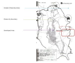
Figure 01: Dhaka City Urban Area Plan – 2005
The local government’s management in Dhaka is ineffective, leading to flooding, traffic congestion, air pollution, and a divide between urban poor and rich. Most land development is controlled by property owners or private developers, resulting in inefficient urban governance. Active expert planning and guidance are needed to address these issues and provide a healthy urban living for residents. Basundhara residential area, located on the eastern fringe of the city, has an approximate area of 5.26 Km2.
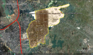
Figure 02: Satellite image of Basundhara R/A in 2002.
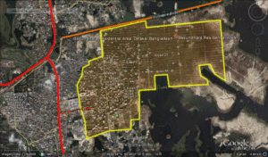
Figure 03: Basundhara R/A, the changed scenario in 2008.
In 2002 the calculated area of Basundhara R/A was approximately 3.21 Km2 where it gets doubled by the year of 2008. According to the proposed layout of Basundhara R/A most of block is still under developed that is covered by wetland and brownfield at present. By the year 2012, the eastern side of the development expanded but the southern part developed comparatively slowly due to wetland and flooding of Dhaka in every year. But EWPD records suggest that by 2015, most of the blocks will be ready to start building construction (http://www.bg.com.bd/EWPD/, 2010).
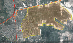
Figure 04: Extended development and new road connection of Basundhara R/A in 2012 (source: edited google earth image).
The above images show the satellite map of Basundhara R/A on 2002 (Fig. 02), 2008 (Fig. 03) and 2012 (Fig. 04). The outline of the area clearly indicates the expansion of the neighbourhoods and encroachment of the adjacent brownfields and lakes. Bangladesh Environmental Preservation Act, 1995 (amended in 2010) suggests that, wetlands filling up will be a punishable offense and East West Properties Development Ltd (EWPD) took a one-year temporary clearance certificate from RAJUK in 2004 to develop Basundhara housing project preserving the canals and wetlands but around N block and periphery areas of Basundhara, EWPD filled up approximately 80,264 m2 of canal for the expansion of their housing project (The Daily Star, 2012b). The following images show the scenario of 2008 (Fig. 05) and 2010 (Fig. 06) at the adjacent areas.Around 2006, a 300 feet wide road (Fig. 07) construction started the northern side of Basundhara Residential Area to connect new town development (Purbachal) to the main artery of Dhaka city. In 2012, it is quite clear that after the construction of the road, Basundhara R/A has not been benefited at all as the accessibility is not yet permitted to the site through that Purbachal Road. So the accessibility of Basundhara R/A is very poor at present as there are only one road in the western side that connects with the artery of Dhaka DIT road. The primary roads (Fig. 08) of the neighborhoods also have no consideration of bus stop, local Centre, public realm or even any street activity.
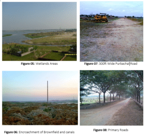
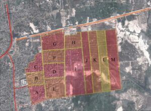
Figure 09: Outline of the Neighbourhoods of Basundhara R/A
East West Properties Ltd. outlined Basundhara residential area into 16 neighbourhood blocks named after A to P (http://www.bg.com.bd/EWPD/, 2010) where N, O and P blocks are yet to be prepared. Figure 09 shows the outline of neighbourhood block of Basundhara residential area. At present 90% of the areas of neighbourhood A, B and C have developed and about 70% of the lands of D, E and F are already in single use development process. These six blocks have developed first as they are in proximity of local facilities such as main road, bus stops, shopping mall, and food or grocery market.
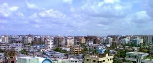
Figure 10: The skyline of Basudhara residential area
According to Dhaka city development authority (RAJUK), Basundhrara development is zoned as a residential use only, thus commercial permission or mixed use building is not allowed within this area (BNBC, 2006). On the other hand, Basundhrara community development authority allows mixed use development in some of the major roads of Basundhara area. So in this conflict, some of the building designed for residential use, converted as commercial building in recent days such as banks, offices, retails and institutions but the arrangement and distribution is abrupt without proper planning (Fig. 10). There are still plenty of open lands that are not yet developed and retrofitting with mixed land use is still possible if local authority and government take initiatives to infill with new mixed-use developments.
According to the above theories (Responsive Environment, Liveable Neighbourhood, Sustainable Neighbourhood, New Urbanist Neighbourhood) discussed earlier, the site (Basundhrar R/A) can be analyzed in different perspectives such as permeability, legibility, variety, robustness, richness, personalization, neighbourhood size, local facilities, adaptability, mixed-use, walkability, safety, provision of public transport, etc. If we consider Basundhara residential area about these criteria, then the current scenario can be drawn to conceptualize the framework of possible retrofit to enhance the environmental quality. The Bangladesh National Building Code (2008) mandates a 1.5m front setback for residential buildings under 33m height, resulting in a lack of green space and community spaces, as well as inactive ground connectivity due to car parking.
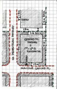
Figure 13: Typical building layout, street scenario of Secondary road of Basundrara
Figure 14: Existing land use and neighbourhood outline of Basundhara R/A.
The existing land use and neighbourhood outline sketch shows the adjacent plot use of primary roads in Basudhara neighbourhoods. According to the above map it is quite clear that most of lands facing the primary roads are only residential use and some of the lands are still open land to retrofit future changes in building typology. Four neighbourhoods out of six that are already developed have institutional buildings where two of them have community halls. The permeability of the site is very poor as there is only one main access to the whole area in the western side. As most of the land is residential use only, the night activity is almost absent in these neighbourhoods and ground floor is used for car parking that also creating a car dependent community. The size of the first six neighbourhoods is justified as the outer radius is about 400m or a 5 minutes walking distance but the distribution of community facility such a surgery, grocery shop, parks, elementary schools, offices and community halls are abrupt and residents can’t reach to their destination without car or other vehicle. The public transport such a tube, tram or even bus service is available within 20 minutes of walking distance. So overall the character of this residential neighbourhood does not offer a sustainable, liveable and environmentally responsive community to its residents that can be retrofitted with mixed use developments for enhancing the existing environment quality and healthy urban living. This study aims to generate a design proposal for retrofit single use neighbourhood to enhance the living environment. First of all, this study will summarize the theories (responsive environment, liveable neighbourhood, sustainable neighbourhood and new urbanist neighbourhood) of study II to draw a conceptual framework for retrofitting residential neighbourhood with mixed use development to enhance the environmental quality. Then according to the framework the possible retrofit will be proposed on the specific site and tested with checklist generated from the theoretical understandings. So this study will finally envision the better future of the Basundhara residential area that will also contribute to improve the design guidelines of future residential neighbourhood of Dhaka city. As the test site is in different context with different culture and environment, the theories should be conceptualized according to the context specific principles. So the following table will produce a checklist for the particular neighbourhood to assess the site and figure out the retrofitting possibilities. The table will help understand the comparisons of different theories and their focus with respect to test site (Basundhara R/A). This comparison will then identify the lacking of different aspect of neighbourhood to explore the retrofit methodology for envisioning better community. The Table 01 shows the degree of presence of different principles in various neighbourhoods
| Theories >>
Principles |
Responsive Environment | Liveable Neighbourhood | Sustainable Neighbourhood | New Urbanist Neighbourhood | Basundhara R/A Neighbourhood |
| Permeability | ● | ● | ● | ● | x |
| Legibility | ● | ◦ | ● | ◦ | x |
| Variety | ● | ● | ◦ | ● | ◌ |
| Robustness | ● | ● | ● | ● | ◌ |
| Visual Appropriateness | ● | ◦ | x | X | x |
| Richness | ● | ◦ | ◦ | ● | x |
| Personalization | ● | X | x | X | ◌ |
| Population | x | X | ● | ◦ | x |
| Open Land | x | X | x | X | ◌ |
| Mixed Use | ◦ | ◦ | ● | ● | ◌ |
| Walkability | ◦ | ● | ◦ | ● | x |
| Public Transport | ◦ | ● | ● | ● | x |
| Safety | ● | ● | ◦ | ◦ | x |
| Environment Responsive | ● | ◦ | ● | ◦ | x |
| Affordability | ◦ | ● | ◦ | ● | ◌ |
- = Strongly Focus ◦ = Present/ partial focus ◌ = Slightly Present x = Absent / do not focus
Table 01 So according to the above table, it can be stated that Basundhara residential area lacks permeability, legibility, visual appropriateness, richness, population control, walkability, public transport, safer street and environmentally responsive initiatives. As there are plenty of open lands available in the neighbourhoods, a proper design guidelines and retrofit implementation can overcome these issues and offer a better community for the future. The retrofit can be done in building scale, human scale and also in neighbourhood scale to ensure the best possible changes to achieve a better community. The existing buildings of Basundhara residential are mostly typical with ground floor car parking and residential units above. The buildings are 6 to 7 storeyed high on average with 1.5m front set back, 1m to the sides and 2m at the back. So a residential street layout produces a monotonous series of tall residential buildings with no active ground floor, pedestrian walkways and no street furniture or even street light.
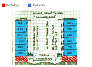
Figure 15: Typical building section with residential street
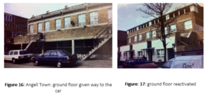
Figure 15 shows that there is no public realm at street level as well as the dead ground floors are a threat for safety and security for the residents at night. The zoned (single use) neighbourhood also does not offer choice and variety to its residents, which led people using the car rather than walk to the nearest facility. A similar example of Brixton’s Angell Town, the ground floor of the building in the whole neighbourhood was given over to the car and the residential units above the ground floor has very little surveillance on street that made the Angell town into ‘Hell Town [1].
The above images show that without demolishing or redeveloping the whole building changes can be made by retrofitting a certain level. Here the variety of functions on the ground floor activated the public realm and surveillance of the street that create a vibrant community. Building scale retrofit can be in minimum level to accommodate different function at various level to create a healthy and lively activity throughout the building as well as street level. So some minor design intervention in building level can enhance the public activity on the street and also encourage people to walk to the common facilities. The frontal part of the ground floor car parking can be converted into small shops or offices that will offer public activity at street level during day and night. The carriageway of the street can be reduced to fit street furniture and on street car parking in one side of the road, which will provide a shaded and pleasant pedestrian pathway.
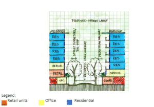
Figure 18: Proposed street and building section
At least the first two floors of each building should be robust enough to incorporate various functions such as retail or office so that the future adaptability of the building offers flexibility and choice to its occupants. At present the secondary roads of the each neighbourhoods do not have any pedestrian walkways, street furniture, bus stop and on street car parking. So the street layouts should also be retrofitted according to the changes of building layout. The retail, office or any type of commercial uses at the ground floor of each building will require more car parking space that can be incorporated on the street. The reduced carriageway will allow spaces for street furniture and pedestrian walkways in at least one side of the road.
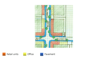
Figure 19: Proposed Street Layout (source: author, 2012)
The ground floor shops and offices should face the road to maintain public surveillance and also create a lively street. There should be some provision for personalization that can also increase the legibility of the neighbourhood. The primary roads of Basundhara residential area is about 9m in width and at present most of the primary roads consists a series of trees in both side but the connected pedestrian pathways, street lamps and other street furniture is still absent. The proposed primary road will have wide pedestrian pathway, street furniture, public transport node and mixed use active ground floor. The buildings adjacent to the primary road should be robust enough to adopt different functions over time. As the climate of the area is hot and humid in most of the time of the year, shaded pedestrian walkways will encourage people to walk.
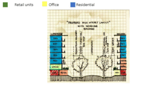
Figure 20: Proposed high street section
Retrofitting in a neighbourhood scale involves the analysis of morphological layers of existing neighbourhood such as the accessibility, legibility, variety, rich mix of housing types, adaptability, walkability, safety, affordability and flexibility of choice. According to the table 01, Basundhara residential area needs to be retrofitted with the above criteria to improve the existing neighbourhood environmental quality. Permeability: Though the road network of Basundhara residential area is grid iron pattern, the periphery of the whole area is not yet connected with the main road. So the existing permeability of the site is very poor. Permeability of this site can be achieved by connecting the primary roads of Basundhara with adjacent main roads. These new connections will reduce the traffic of existing western primary road.
Figure 21: Proposed bus stops that cover most areas in 5 min walking distance
Most buildings in Basundhara are six-storey single-use residences, producing a monotonous street layout with little regard for corners or nodes. The gridiron road pattern and uniform plot sizes further limit orientation. Retrofitting communal facilities at strategic points can improve legibility, allowing residents to navigate easily and fostering a sense of belonging. Because the area is zoned for single use, variety is largely absent. A few residential buildings on main roads have been converted to mixed use, but distribution is poor. Introducing a diverse mix of housing and functions within walking distance would create a vibrant community and encourage walking. Basundhara shows potential for adaptability. Open lands could be redeveloped into mixed-use buildings, public parks, schools, offices, and community halls, allowing the neighborhood to evolve with future needs. Currently, the area lacks walkability. Facilities and transport nodes are far from residences, discouraging walking. Retrofitting should ensure schools, parks, bus stops, shops, and community halls are within five minutes’ walking distance of households. Although individual buildings employ security guards, neighborhood safety remains weak. Streets are inactive at night due to car-dominated ground floors and absent public realm. Introducing shops, restaurants, parks, and leisure activities would activate public spaces and provide natural surveillance. Affordability is also key. A socially mixed community would support diverse facilities and promote sustainability. With minimal intervention, Basundhara can be retrofitted: mixed-use typologies encouraged on open land near primary roads, while interior plots provide schools, centers, parks, and playfields.
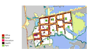
Figure 22: Proposed retrofitted master-plan of Basundhara Residential Area
The figure 22 shows the proposed retrofitted neighbourhood master-plan for Basudhara residential area. The master-plan shows the possible retrofit option at neighbourhood scale such as proper distribution of communal facilities (schools, community halls, parks, retails, heath care services and surgery), retrofitting street layout to accommodate public transport nodes and mixed use building adjacent to primary roads. According to [2], a neighbourhood should comprised with surgery, primary school, green network, tram, local center, parks, bus stop and playground within 400m to 1000m distance from every home. A neighbourhood should be shaped according the distribution of these communal facilities and a diverse – vibrant neighbourhood will have rich mix of housing types to support these functions. So the proposed master-plan of the Basundhara residential area offers most of these communal facilities within 1000m that will create a healthy, vibrant community.
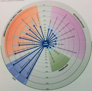
Figure 23: Neighbourhood and small town structure
This study discussed about various retrofitting scale of Basundhara residential area. To retrofit a zoned (single use) neighbourhood, building and street level retrofit is necessary to support the changes of neighbourhood scale. The buildings are to be retrofitted with mixed use so that people can have variety of choices to a walking distance and these mixed-use building also help the street become more lively during day and night. Retrofit building with mixed-use will also effect on the street level activity and can require higher volume of pedestrian and car parking. So the second level of retrofit should be done in street/block scale to adopt the changes made from building retrofitting. The street can be retrofitted by reducing the carriageway width and adding shaded pathways for the pedestrian. The on street car parking and street furniture will also improve the street environment and encourage people to walk to a nearest distance. Then retrofit in neighborhood scale will focus on the physical distribution of communal facilities from residential occupants. Not all the buildings are to be retrofitted in a neighbourhood. Firstly, the neighbourhood size is to be determined and the hierarchy of roads should be implied. Then mix of housing types can be designed alongside the primary roads of each neighbourhood, which will offer legibility and variety to its residents. Each of the neighbourhood should be interconnected and dependent with each other for different functions so that a healthy communication and lively public activity maintained throughout the whole residential area. The distribution of the communal facilities will be determined by the culture specific requirements.
- CONCLUSION
This study concludes by analyzing the impact of implementing the proposed design on the specific site, assessing both barriers and future possibilities. The aim was to develop a methodology for retrofitting single-use neighborhoods to mitigate sprawl, increase walkability, reduce carbon footprint, enhance environmental quality, diversify land use, and reduce crime through mixed-use building surveillance. The study first reviewed global urban design theories and practices, selecting four existing guidelines to test their applicability. A five-layer framework was then applied: (1) defining urban design theories related to single- and mixed-use neighborhoods, (2) generating a conceptual framework for site analysis, (3) refining design principles to suit the site, (4) proposing retrofit techniques, and (5) evaluating implementation against theory and practice. Findings identified three levels of retrofit: (1) building scale, allowing minimal interventions like adding mixed-use functions at lower levels to activate public spaces, (2) street/block scale, requiring collective action along primary roads, and (3) neighborhood scale, needing authority, community, and private landowner collaboration. Retrofitting is a long-term process, varying with intervention levels. Limitations included time constraints, limited site data, and lack of official planning guidelines for Basundhara, as the area was largely developed privately. Maps and sketches were generated from Google Earth, limiting precision. Resident and stakeholder participation, crucial for retrofitting, could not be tested due to unavailable responses. Future work should implement the proposed design on-site and survey community reactions. Observing public movement, economic shifts, and social interactions will provide insights into the feasibility and long-term success of retrofitted neighborhoods.
REFERENCES
- Pia, N. A. (2022). Rethinking residential neighborhood in Dhaka, Bangladesh: Jane Jacobs’s urban design principles for improving livability. In Urban and transit planning: Towards liveable communities: Urban places and design spaces(pp. 213-223). Cham: Springer International Publishing.
- Fatemi, M. N., Islam, Z. H., & Rahman, T. (2024). Improving Liveability Through Regenerating Informal Neighbourhoods: A Case of Old Dhaka, Bangladesh. In Innovative Public Participation Practices for Sustainable Urban Regeneration(pp. 83-97). Singapore: Springer Nature Singapore.
- Shawon, M. T. A., Mahmud, M. A., Rahman, M. M., & Ubaura, M. (2021). Building Vulnerability Assessment and Social Appraisal of Retrofit in Lalmatia, Dhaka. The Jahangirnagar Review, Part II: Social Sciences, ISSN, 1682-7422.
- Dalal, R., & Kumar Saini, D. (2023). Mitigation of the impacts of electric vehicle charging on energy-star ratings for residential buildings in India. Clean Energy, 7(5), 981-993.
- Mazumder, R. K., Rana, S., Wang, X., Ansary, M. A., & Li, Y. (2025). Community-Level Seismic Risk and Retrofitting Portfolios in Developing Countries: Cost-Effective Assessment Framework and Application. Natural Hazards Review, 26(2), 05025003.
- Hasan, M. M., Moznuzzaman, M., Shaha, A., & Khan, I. (2025). Enhancing energy efficiency in Bangladesh’s readymade garment sector: the untapped potential of LED lighting retrofits. International Journal of Energy Sector Management, 19(3), 569-588.
- Mahfuj, I. I., Tamim, N. F., Abdul Aziz, Z. A. B., Salan, M. S. A., & Islam, M. (2025). Redesigning Karwan Bazar MRT Station as a Transit-Oriented Development (TOD) Neighborhood: A Mixed Land Use Approach. Available at SSRN 5182917.
- Dhaka, E. (2023). Bangladesh| EAST DHAKA. Private Cities: Outstanding Examples from Developing Countries and Their Implications for Urban Policy.
- Shawon, T. A., Rahman, M. M., Ahmmed, M. Z., & Mahmud, M. A. (2021). Earthquake Vulnerability Mapping using Binary Comparison Matrix and Analytical Hierarchical Process (AHP) in Lalmatia, Dhaka.
- Moniruzzaman, M., Minhaz, S., & Siam, I. (2024). Developing Regional Seismic Fragility Curves Using ETABS for a Multi-Storey Residential Building. Struct. Technol, 9, 6-14.
- Sultana, R., Ahmed, Z., Hossain, M. A., & Begum, B. A. (2021). Impact of green roof on human comfort level and carbon sequestration: A microclimatic and comparative assessment in Dhaka City, Bangladesh. Urban Climate, 38, 100878.
- Islam, S., Alam, M. R., & Rashid, K. J. (2023). Identification of potential rooftops for gardening and contributions of RTGs to improve the socio-economic condition and promote a sustainable urban environment in the changing climatic condition of Bangladesh. In Urban Commons, Future Smart Cities and Sustainability(pp. 511-532). Cham: Springer International Publishing.
- Rumi, M. H., & Sujana, N. J. (2023). DOMINANT URBAN ENVIRONMENTAL ISSUES-INDUSTRIAL FIRE AND EARTHQUAKE.
- Saha, K. K., Shil, A., & Champa, A. D. Discriminatory Developments: Unveiling Marginalisation in Revitalised Public Spaces in Dhaka City.
- Rahman, M. M., Khan, S. J., & Tanni, K. N. (2022). Holistic individual preparedness in an urban fire-prone area: The case of Dhaka City, Bangladesh. International Journal of Disaster Risk Reduction, 81, 103274.
- Choudhury, Z. F. (2021). Nodes and Streets: Exploring the Pedestrian Mobility Pattern in the Intersection of the Streets in Dhaka City. Nakhara: Journal of Environmental Design and Planning, 20(1), 107-107.
- Mizanuzzaman, M., & Waheduzzaman, M. Conception Survey on Willingness to Pay for Improved Air Quality in Dhaka City, Bangladesh.
- Lucas, K., Mitullah, W., Nasrin, S., Rahman, F., Opiyo, R., & Tsoneva, E. (2025). ‘Talk the Walk’: The co-design of socially sustainable mobility solutions in informal settlements. Journal of Urban Mobility, 7, 100112.
- Islam, M. I., Hossain, M. R., Sagar, M. R., & Nasrin, T. (2025). Seismic Retrofitting Column and Beams With Carbon-fiber Reinforced Polymer Using Etabs to Resist Earthquake Drift and Magnitude According to Bnbc 2020.
- Iqbal, A., Jahan, I., Wasiew, Q. A., Emu, I. A., & Chowdhury, D. (2023). From existing conventional building towards LEED certified green building: case study in Bangladesh. Frontiers in Built Environment, 9, 1194636.
- Uddin, M. M., Hossain, S. N., Shawon, T. A., Fahim, A. U., Sharmin, S., & Rahman, M. M. (2023). ADDRESSING THE FIRE SAFETY PROBLEMS IN SHOPPING CENTRES OF DHAKA CITY: A CASE STUDY ON SOME SELECTED SHOPPING CENTRES IN MIRPUR AREA.
- Ashik, F. R., Sreezon, A. I. Z., Rahman, M. H., Zafri, N. M., & Labib, S. M. (2024). Built environment influences commute mode choice in a global south megacity context: Insights from explainable machine learning approach. Journal of Transport Geography, 116, 103828.
- Podder, M., Hasan, M. K., & Islam, M. J. (2022). Seismic Vulnerability Assessment of Existing Buildings by Rapid Visual Screening Method: A Study on Ward 27 in Dhaka South City Corporation. International Journal of Disaster Risk Management, 4(2), 77-91.
- Chowdhury, R. (2025). Potential of Urban Agriculture in Bangladesh: A Case Study in Dhaka(Doctoral dissertation, © University of Dhaka).
- Minhaz, M. S. B., & Awall, M. R. (2024). A COMPARATIVE ANALYSIS USING BRICK CHIPS CONCRETE IN STRONG STOREY AND STONE CHIPS CONCRETE IN SOFT STOREY.
Publication History
Submitted: March 04, 2025
Accepted: March 30, 2025
Published: March 31, 2025
Identification
D-0442
DOI
https://doi.org/10.71017/djsi.4.03.d-0442
Citation
Shihab Amin Mustafa (2025). Retrofitting Dhaka’s One of the Largest Residential Neighborhoods. Dinkum Journal of Social Innovations, 4(03):158-174.
Copyright
© 2025 The Author(s).